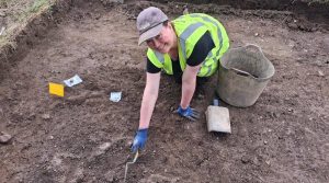
Excavation along the new Cork motorway has revealed important archaeological finds, including Stone Age and Bronze Age houses, Bronze Age burial activity, medieval settlements and what is believed to be “Cork’s earliest roadside service station”.
Over the past 18 months or so, archaeologists excavating along the path of the new M28 motorway in Cork have made significant discoveries spanning thousands of years. Among the finds are a dwelling belonging to Neolithic farmers, Bronze Age houses and cremations, early and late medieval settlements, and a post-medieval roadside ironmongery.

Neolithic finds
The earliest discovery is the rectangular foundation of a typical Early Neolithic house constructed approximately 5,700 years ago. It was found near the quarry on the border of the townlands of Raffeen and Ballyhemiken, not far from the village of Shanbally.

Before this road project, there were no known Neolithic sites or monuments within the vicinity of the proposed M28 route, though two Neolithic stone axe-heads had been previously found in Carrigaline.
Also recovered during the road project were sherds of carinated bowls, the earliest type of pottery known in Ireland.

The Neolithic house is the ninth of its kind unearthed in Co. Cork; all others were also revealed during road schemes. These dwellings, likely inhabited by some of the first farmers in the region, shed light on the transition from a nomadic hunter-gatherer society to a more settled farming community engaged in livestock herding and crop cultivation.
Bronze Age and Iron Age finds
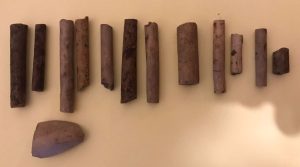
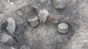
Remnants of Bronze Age houses were identified in the townlands of Raffeen and Barnahely; sherds of pottery from these sites facilitated their dating to the Middle and Late Bronze Age. Additionally, the excavation yielded evidence of Bronze Age cremations in the townlands of Loughbeg, Ringaskiddy and Carrigaline Middle.
One of these sites appears to have operated as an organized cemetery comprising clusters of cremations, probably during the Early Bronze Age. It seems that the cremated remains were covered in stone-lined pits by vase urns, with food vessels placed alongside the inverted urns, likely intended to sustain the deceased in the afterlife.
>>> YOU MIGHT ALSO LIKE: Roscommon’s forgotten cemetery: excavation results at Ranelagh revealed
A couple of possible ring ditches of Bronze Age or Iron Age date, several fulactaí fiadh and a number of prehistoric grain-storage pits – often filled with charred grain and broken pieces of saddle querns – were also investigated during the road project.
Medieval and post-medieval finds
Not all of the discoveries, however, were prehistoric in nature. The motorway falls within the territory of the Ciarraigha-Cuirche and a number of early medieval ringforts were already recorded in the area. However, previously unknown enclosed sites of this period came to light during the excavations in the townlands of Ballinrea and Barnahely.

The latter was a large multi-enclosure complex probably of high status. The considerable quantity of slag recovered from part of the site suggests its significance as a centre for metalworking, while cereal drying was also carried out. Radiocarbon dating places its occupation in the 7th to 9th centuries AD but it was likely multi-period.

A possible enclosed rectangular farmstead, surrounded by several field systems, was identified in the small townland of Ballinimlagh. It was probably inhabited between the 13th/14th and 17th centuries.
Just west of the Shannonpark roundabout, the remains of a sizable 17th-century forge were uncovered. It would have catered to the needs of the local population as well as providing cart repairs and forging horseshoes for passing travellers between Cork city and Carrigaline or Ringaskiddy. It has been dubbed “Cork’s earliest roadside service station”.

Several shell middens were investigated during the road project and these could also date to the late or post-medieval period. They simply indicate the consumption of shellfish, which is not surprising given the coastal location.
The M28 Cork to Ringaskiddy Project
The M28 Cork to Ringaskiddy Project pertains to the upgrade of a 12.5km stretch of the N28 National Primary Route in Co. Cork, extending from the N40 South Ring Road at the Bloomfield Interchange to Ringaskiddy. Cork County Council is delivering the project on behalf of Transport Infrastructure Ireland (TII) and it is scheduled to be completed by 2030.

The highly productive archaeological excavation, executed by a team of approximately 50 archaeologists employed by Rubicon Heritage and overseen by TII Project Archaeologist Ken Hanley and Cork Count Council Resident Archaeologist Ed Lyne, involves an impressive 50,000 linear meters of test trenches covering an area of roughly 102,000m2 and 38 distinct archaeological sites.

Further post-excavation research will be carried out in the coming months, including radiocarbon dating to ascertain more precise dates for the uncovered features. No doubt, these findings will enrich our understanding of the origins and evolution of settlement on the Ringaskiddy Peninsula and wider Cork region.
READ NOW
➤ Excavation of Sligo’s Green Fort yields over 1,000 finds from 17th-century bastioned military fort
➤ Excavations at Moylisha wedge tomb in Wicklow
➤ Roscommon’s forgotten cemetery: excavation results at Ranelagh revealed
➤ Ireland’s holed stones: swearing, oath-taking and healing
➤ In Waterford archaeologists are excavating what may be the largest Viking building found in Ireland