The history of the Grand Canal can now be explored through an interactive digital map that traces the route from Dublin’s docklands to Shannon Harbour using archival material and multimedia content.
The history of the Grand Canal has been brought to life through an interactive digital map developed by Waterways Ireland, offering users a virtual journey along one of the country’s most important inland waterways.
The Grand Canal, completed in 1804, was a marvel of engineering and a crucial artery for trade and passengers. It enabled the flow of goods, such as agricultural produce and coal, between Dublin and the heart of Ireland. Along the way, the canal became a bustling thoroughfare, with canal hotels emerging to accommodate the many travellers.
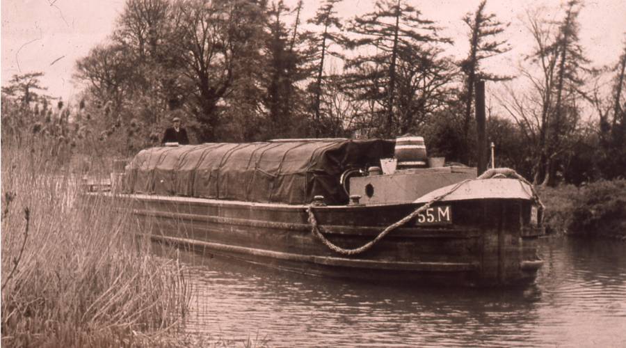
Released in May, the storymap, titled A Boatman’s Journey, follows a boatman travelling the 130km waterway aboard a barge designed specifically for the Grand Canal in 1925. Up until the 1920s, boats on Ireland’s canals were horse-drawn, while those on the River Shannon were pulled by steam. By 1927, horse traffic on the Grand Canal had come to an end, making way for the increased use of motorized boats powered by Bolinder engines, marking a significant shift in the canal’s operational history.
>>> YOU MIGHT ALSO LIKE: Shipwrecks of Dublin Bay exhibition opens at Dublin Port
Beginning at Dublin’s docklands, the boatman passes locks, bridges and aqueducts, as well as landmarks including the Guinness Brewery, before crossing the Bog of Allen, travelling through towns including Edenderry and Tullamore before ending at Shannon Harbour.
Developed using Esri Ireland‘s ArcGIS technology, the interactive map combines historical documents, photographs, oral histories, verbal anecdotes, 3D animations and video clips linked to locations along the canal. Much of the material is drawn from the Waterways Ireland archive.
Users can click on locations along the route to explore how the canal was built, learn about the lives of those who worked aboard its barges a hundred years ago and discover the history associated with individual places along the waterway. The project aims to help people develop stronger connections with the canal through their local communities and family histories. The map also serves as an educational resource, with Waterways Ireland producing lesson plans linked to the school curriculum.
Waterways Ireland is responsible for restoring, developing and promoting more than 1,100km of inland waterways across Ireland and Northern Ireland. It plans to develop more digital stories covering the other waterways under its management.
A F F I L I A T E A D

You can access the Grand Canal storymap here.
Advertising Disclaimer: This article contains affiliate links. Irish Heritage News is an affiliate of FindMyPast. We may earn commissions from qualifying purchases – this does not affect the amount you pay for your purchase.
READ NOW
➤ Irish connections with the doomed “Millionaires’ Ship”, the RMS Republic
➤ Remembering William Deans, the Dublin docker who received two bravery awards
➤ Peter O’Connor, the “Irish Antelope” and his record-breaking jumps
➤ In Waterford archaeologists are excavating what may be the largest Viking building found in Ireland
➤ Virtual Treasury adds 194,000 more records, taking total past half a million